iWhat is BangkaNav
BangkaNav turns your phone into a safety companion at sea.
It quietly records where you go on a trip, shows your local sea & weather, lets you mark your fishing spots, and gives you a one-tap SOS that alerts your local rescue team with your location — even after you lose signal. Your barangay/municipal office can see that you're out and help find you fast if something goes wrong.
1Getting started
Install & open the app
Install BangkaNav on your Android phone and open it. The first time, you'll choose your language and create your account.
Register (one time)
- Tap Register on the welcome screen.
- Enter your full name and mobile number (your number is also your login).
- Choose your municipality/city and barangay from the list.
- Create a password (at least 8 characters).
- Read and accept the data-privacy notice, then tap Create account.
Logging in
Enter your mobile number and password. You stay logged in afterwards, so you can open the app and go straight to the map — even with no signal.
2Location & permissions
BangkaNav asks for a few permissions so it can keep you safe. Please allow them:
- Location (Allow all the time) — so your trip keeps recording with the screen off, and rescuers can find your last known spot.
- Notifications — so you see the "recording trip" reminder and any safety alerts.
- Battery: don't optimize — on some phones (OPPO, Vivo, Xiaomi), allow BangkaNav to "run in background" / turn off battery saving for it, so tracking isn't stopped at sea.
3Your home screen
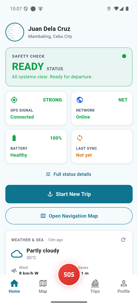
A quick safety check before you head out.
Safety status
READY means GPS, network and battery look good. CAUTION warns about weak GPS or low battery — fix it before leaving.
GPS signal
Shows if your location is locked. "Searching…" means wait a moment under open sky.
Network
Online/offline. Offline is fine — your trip still records and syncs later.
Battery
Keep it healthy. Low battery can stop tracking.
Weather & sea
Local conditions (rain, wind, waves). Tap refresh for the latest; it updates by itself too.
Last sync
When your data last reached the server. "Not yet" simply means it will sync when you get signal.
4Recording a trip
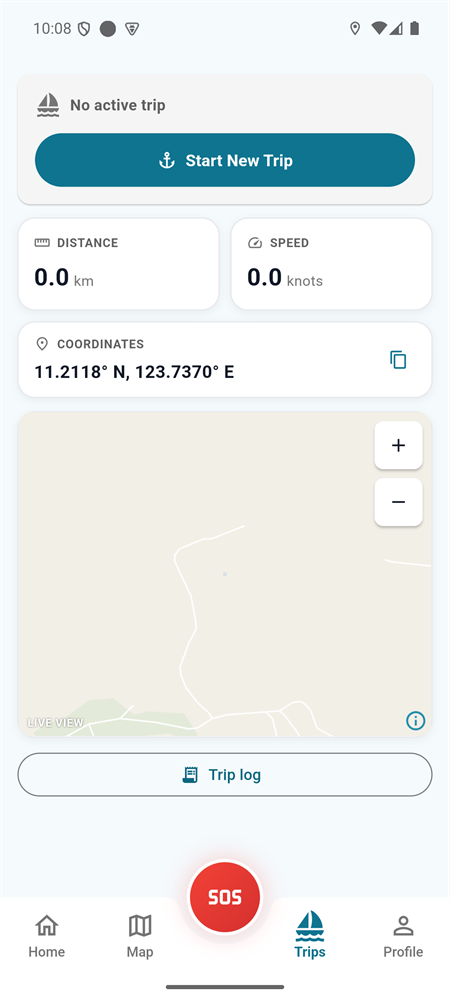
This is the most important habit — start a trip every time you go out.
- Before you leave, on the Home screen tap Start New Trip.
- Fish as usual. BangkaNav records your route in the background — even with the screen off or the app closed, and even with no signal.
- You'll see a small "BangkaNav — recording trip" notification while it's running. That's normal; leave it on.
- When you're back, open the app and tap End Trip.
5Map & offline maps
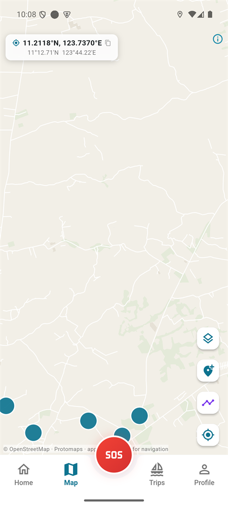
The Map tab shows your position and which way you're facing, plus optional layers:
- Depth — approximate water depth.
- Currents — prevailing sea-current paths.
- Your markers — fishing spots, nets, anchors.
Download maps before you go out
So the map works far from shore with no signal, download your area while you still have Wi-Fi or data. Open the map layers and tap the download option for your region.
6Fishing spots & nets
Mark places you want to remember. They're saved to your account and shown on your map.
- Net drop, fishing area, anchor point, trap — drop a marker at your current spot and add a short note.
- Net trail — record the line of a net you lay, kept separate from your travel route.
!Emergency SOS
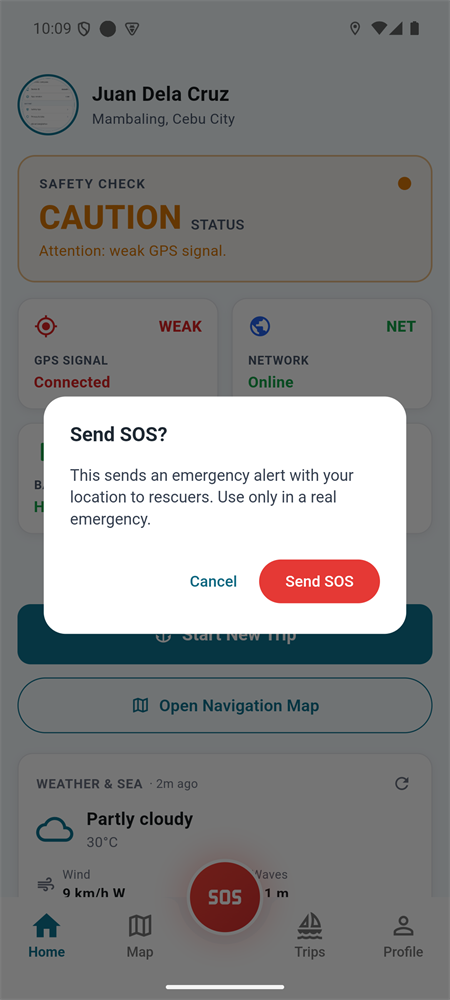
What happens when you send an SOS
- Your rescue/LGU responders are notified right away and can see you on their map.
- Your location keeps updating to them until the emergency is resolved.
- If you have weak or no signal, the SOS is saved and sent the moment any signal returns.
When you're safe again
If you're rescued or no longer need help, open the SOS and tap "I'm safe" to stand it down. Responders are told you're okay.
6Working offline at sea
BangkaNav is built to work without signal:
- Your trip route, markers, and any SOS are saved on your phone when you're offline.
- The moment signal returns, everything uploads automatically — you don't need to do anything.
- You can keep using the map and recording the whole time.
7Profile & settings
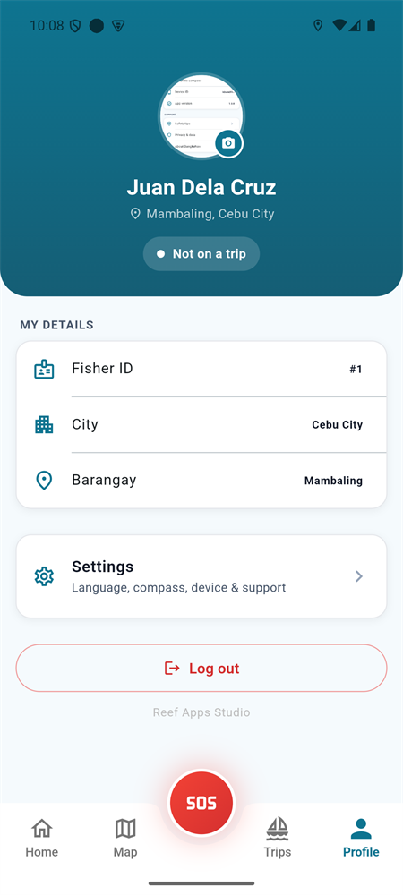
Profile photo
Open Profile, tap your photo, and take or choose one. It's saved to your account, so it follows you to a new phone.
Language
Settings → Language — switch between English, Tagalog and Cebuano any time.
Calibrate compass
Settings → Calibrate compass if your heading arrow drifts.
Report a problem
Profile → Report a problem — describe what went wrong and tap Send. Technical details about your phone and your recent recordings are attached automatically, so the team can find the cause without borrowing your phone. No signal? It's saved and sends itself later.
Log out
End any active trip first, then log out from the Profile screen.
8Privacy & your data
- Your location is recorded only between Start Trip and End Trip — never when you're not on a trip.
- An active SOS keeps sharing your location until it's resolved, so rescuers can reach you.
- Only your own LGU's authorized officers can see your information.
- Handled in line with the Data Privacy Act (RA 10173).
9For LGU officers & rescuers
Coastal LGUs and rescue teams use the web dashboard to see active fishers on a live map, respond to SOS alerts (acknowledge → rescue → resolved), and review trip history — all scoped to your own area.
Open the dashboard → (staff login required)
?Frequently asked questions
Does it work without internet?
Yes. Your trips, markers and SOS are saved on the phone and upload automatically when signal returns. Download your map area before heading out.
Will it keep recording with the screen off?
Yes — keep the "recording trip" notification on and allow background/location "all the time". On some phones you also need to turn off battery optimization for BangkaNav.
I got a new phone. Do I lose everything?
No. Log in with your mobile number and password and your profile, photo and history come back from the server.
Does the SOS work if I have no signal?
The SOS is saved instantly and sent the moment any signal returns. It cannot reach responders while you're completely out of mobile range, so stay within known coverage and tell someone your plan.
Does it drain my battery?
BangkaNav records efficiently, but GPS uses power. Start a trip when you leave, end it when you return, and bring a power bank for long trips.
The direction arrow won't turn.
Open Settings → Calibrate compass and move the phone in a figure-8 a few times.